Advancing Disaster Risk Management: Insights from Barcelona’s Workshop and Galileo’s SaR and EWSS
Stakeholders from public authorities, research institutions, civil protection, rural agents, firefighters, maritime rescue, and the private sector convened on 26 February 2025 at the World Trade Center of Barcelona to understand how satellite technologies can address disaster risk management challenges. Part of a series of national workshops initiated by the European Union Agency for the Space Programme (EUSPA) and supported by Eurisy to raise awareness on the many possibilities offered by the EU space Programme for disaster risk management, the event highlighted the potential of satellite applications in enhancing Spanish and Catalan response and risk reduction capabilities amid rising risks from floods, wildfires, and earthquakes. Co-organised with relevant national and regional entities the Institute of Space Studies of Catalonia (IEEC), Secretariat for Digital Policies of the Government of Catalonia, and Spanish Space Agency (AEE), the workshop supported both increased national resilience and the growth of Spain’s space technology ecosystem.
Spain faces a range of significant disaster threats stemming from its geographic location and the impacts of climate change. Between 2012 and 2024, the Copernicus Emergency Management Service (CEMS) Rapid Mapping was activated 115 times by Spain, the most by any country, with wildfires being the most frequent cause, followed by floods, most notably during heavy storms experienced during October 2024 resulting in the tragic loss of 219 lives. 2024 also saw Spain activating Galileo, the European Union’s satellite navigation and positioning system, Return Link Service (Search and Rescue) beacons 42 times in incidents during which 172 lives were saved.
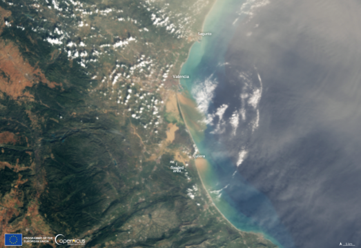
Figure 1 – European Union, Copernicus Sentinel-3 imagery
Under the moderation of Eurisy Secretary General, Graham Turnock, the introductory session outlined the significance of using space for disaster risk management. Maria Galindo, Secretary for Digital Policy of the Government of Catalonia, emphasised the role of the Catalan Government in leveraging satellite technologies for the benefit of society, “Emergency management is a critical area where space technologies can provide a unique value. Events like this [workshop] are essential to connect the space sector with end users and ensure that satellite-based solutions address real and specific needs.” Building on this idea, Juan Carlos Cortés, Director of the Spanish Space Agency (AEE), underscored the global nature of disaster management challenges and the vital role of space to address them. He stated that “Disaster management presents a global challenge demanding equally global solutions. Space offers a unique perspective to tackle this, particularly given that a sense of security is a major concern for citizens today, […] ranging from climate change and the danger of asteroid impacts to volcanic eruptions, wildfires, and floods.” From the European perspective, Rodrigo da Costa, Executive Director of EUSPA, underlined the importance of the role of the Agency and its programmes in this endeavour “With more than 4 billion Galileo-enabled devices worldwide, EU space technology is now an essential tool in disaster risk management. The EU Space Programme provides critical support for emergency response, helping authorities make faster, data-driven decisions that save lives and protect communities. By leveraging Copernicus, GOVSATCOM and Galileo for precise positioning and emergency alerting, we are strengthening Europe’s resilience against natural and manmade disasters”. Highlighting the collaborative efforts made at the multiple levels to drive innovation in the space sector, Ignasi Ribas, Director of the Institute of Space Studies of Catalonia (IEEC), concluded “Today’s event is a demonstration of the effort we [IEEC and Generalitat] are making to promote cooperation at the state, European, and international levels, to drive the transformation of our society through the new space economy, and to address the climate emergency.”
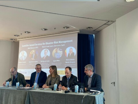
From left to right: Graham Turnock (Eurisy), Juan Carlos Cortés (AEE), Maria Galindo (Government of Catalonia), Rodrigo Da Costa (EUSPA) and Ignasi Ribas (IEEC)
After highlighting the stakes and importance of this workshop series, more than 100 participants listened to EUSPA representatives presented the importance of Galileo, Copernicus, GOVSATCOM, IRIS² and EU SST for disaster risk management. The opportunities of the Cassini funding were also explained. Panel discussions explored Spanish cases involving wildfires, floods, and earthquakes, presenting national efforts and challenges in preparedness and response. The first thematic panel featured space companies showcasing practical applications of satellite data in support of the disaster management cycle and their integration into daily workflows. The second focused on emergency system users sharing experiences, highlighting the benefits, challenges, and opportunities to enhance satellite data accessibility. Discussions drew on Spanish case studies and best practices to outline actionable recommendations for policymakers and civil protection agencies, strengthening collaboration between service providers and end-users. If you were unable to join us in Barcelona, you can view the presentations here.
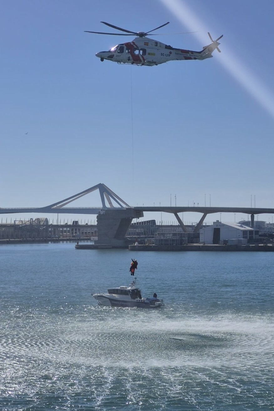
The workshop also provided the opportunity to witness two demonstrations to showcase the real-time capabilities of space technology in providing a rapid response in emergency situations.
The first demonstration was a Search And Rescue (SAR) exercise, in which SASEMAR (a sea search and rescue agency that operates in Spain), supported by the Mossos d’Esquadra and the fire brigade, deployed two boats and a rescue helicopter to simulate a real-time maritime assistance operation. The Galileo SAR Service operates quickly to locate and help people in distress that activate a beacon. The demonstration aimed to highlight the effectiveness and speed of Galileo SAR Service and its Return Link Service (RLS), on average 37 seconds up to maximum 10 minutes, as key tools in maritime rescue operations. After the activation of the beacon on the boat, the signal was received in the control center which locates the signal and then notify the relevant SAR authorities. An acknowledgment message was also sent to the beacon informing the users on the boat that their request was well received. Once the SAR authorities arrived, here SASEMAR, the participants witnessed the rescue live.
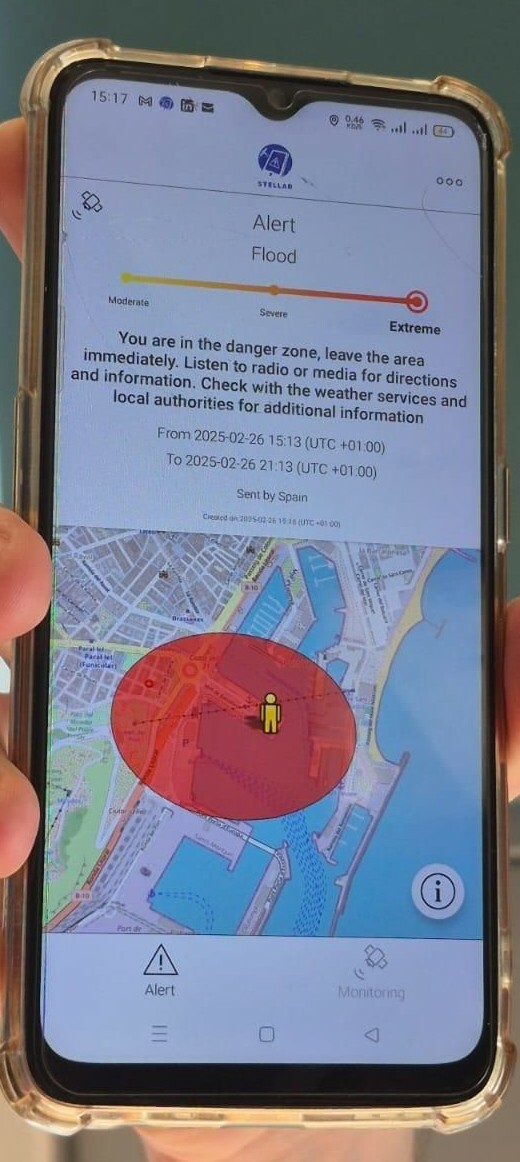
In the afternoon, the audience had the opportunity to experience the upcoming Galileo Emergency Warning Satellite Service (EWSS). This technology is in its testing phase and will become the future means of precise mass alert messaging to populations in areas threatened by natural or manmade disasters, improving current capabilities. Using the European Union’s Galileo satellite navigation system, this service will transmit safety information directly to smartphones and navigation devices, even when other terrestrially based alert systems are unavailable or in areas with no coverage, thus improving risk zone delineation and extending the reach of protected populations. By ensuring the distribution of alert messages and guidance, the EWSS will enhance the connection between users and space, increasing rescue capabilities in large-scale emergencies and safeguarding populations at threat. The participants witnessed the pilot test of the service and saw an alert arriving in real time on the pilot phones, highlighting the type of disaster, its severity, its timeframe and the zone of danger with a message explaining the situation. The test also showcased that the alert message arrives in the language the phone is set to, thus ensuring the understanding of the emergency by everyone.